Beyond Borders
The Companion website
Temples of Angkor, Lunacy of Polpot
Saigon to Siem Reap
Saigon was already buzzing when I boarded a bus to Cambodia at 6 AM
one Tuesday morning. Hundreds of mobikes plied the streets even at
that early hour. My bus quickly negotiated the early morning city
traffic and set off in the direction of the Vietnam-Cambodia border.
We covered the 70-kilometer distance to the border town of Bavet in 90
minutes, and I soon found myself standing in line at the immigration
office on the Cambodian side.
A few days before my journey, I had procured a Cambodian visa within
minutes over the Internet. I had to just fill a form, upload a
photograph, and provide a credit card number - and the "e-visa" had
arrived as an image file to my email address. The entry procedure into
the country was a far cry from the sophisticated on-line electronic
visa issual system, however. When I reached the head of the queue, the
immigration officer directed me to another table that handled e-visas.
The concerned officer, though, was not in the vicinity. After a while,
the original officer arrived and manned the desk, but the computer did
not recognize the bar code imprinted on my visa. While waiting for a
resolution for the next half hour, I saw several mysterious
transactions - many travel agents were handing out currency notes to
immigration officers. Thankfully, the officials finally found a way to
manually enter my visa details into their system and let me enter
Cambodia.
The bus - that had been patiently waiting for me during my extended
immigration session - soon halted for breakfast at a crowded roadside
eatery. I spotted vegetable noodles on the menu, which cost me 6000
Reals. Coffee came for another 2000 Reals. The U.S. dollar, worth
about 5000 Reals during the time of my visit in 2009, was as prevalent
in Cambodia as the country's own currency, the Real. One could pay in
dollars and receive change in Reals or vice versa. That was the case
all over Cambodia and not just in touristy areas. ATMs churned out
either U.S. dollars or Real bills depending on customer preference.
That the dollar was in widespread use was evident by the language
spoken by advertisements. Cellular service provider Star Cell's
billboards enticed: "Get 500 minutes for $5".
Khmers - as ethnic Cambodians are called - do not fully trust their
banks because of the frequent currency devaluations and wild
fluctuations that they have experienced in the past. Currency was in
fact, totally abolished in the late 1970s during Pol Pot's regime. The
dollar, in comparison to the Real, is considered stable and solid.
I shared my restaurant table with two co-passengers. One of them who
hailed from Spain's separatist Basque region made it known in no
uncertain terms that though he was technically from Spain, he did not
recognize Spanish rule. He worked in the city of Bilbao for auto giant
Volkswagen. Basque language, he claimed, was the oldest in Europe.
Five million people lived in the Basque region that spanned areas of
Spain and France, he informed. The other co-passenger was a young man
from Tokyo who had come to Saigon on business. He had left Microsoft
after a 2-year stint to start his own business analytics and web
design company. After finishing his work in Saigon, he had purchased
his first backpack. His plan was to visit Siem Reap and then continue
by road to Bangkok.
As my bus rolled into Cambodian hinterland, the landscape looked the
same as in Vietnam. The style of construction was distinct, however.
Most houses that I saw in the countryside were thatched; the poorer
ones were sheeted. The occasional "designer" buildings sported the
classic Cambodian signature on the roof - a cluster of tapering
strands shaped like fire. A majority of the houses were built on
stilts and the resulting basement - the coolest part of the house -
was used as a multi-purpose area to hang hammocks, hold cots, park
two-wheelers, dine, or perform household chores. Some houses even
converted the basement into a cow shed. A staircase connected the
basement to the main entrance above. The stilts and the stairs were
made of either wood or concrete depending on the structures they
supported.
Larger buildings such as schools were built over regular foundations.
Schools that I saw on the roadside were all housed in basic buildings,
but sported western names - London school, Washington International
School, and Asia American school, to name some. There was an ongoing
campaign in the country to spread awareness of the importance of
education. A hoarding advised: "School is the best place for work, not
fields, not factories".
The rolling rice fields, water bodies, buffaloes, and farmers looked
no different from across the border, except that the latter didn't
wear Nons. Temples appeared at regular intervals. Vietnamese
Chuas and Pagodas became Wats in Khmer land, but
the deities remained the same. The wats looked opulent and unique -
horns having a wavy design marked the edges of their roofs. I even saw
a wat-on-stilts in the middle of a small pond. Cambodians seemed more
religious than the Vietnamese - the Wat penetration rate seemed much
higher on this side of the border. We passed bountiful flora -
bougainvillea, shoe flower, and fruit trees of plantain, mango,
papaya, date palm, coconut, and jack; and many other plants and
creepers that I could not recognize.
That Cambodia today is a multi-party democracy unlike its eastern
neighbor was clearly perceivable on the streets. Hoardings of the
Cambodian People's Party was visible every few hundred meters; that of
Sam Rainsy party and Funcipeck party could be seen less often.
In small towns where the bus stopped to let passengers use restrooms,
abject poverty was evident. It was common to see 7 or 8 year old kids
holding naked babies with protruding bellies begging for food or
money. This was different from the green, sparsely populated
countryside that thrived on agriculture - rural life looked simple and
spartan, but didn't display overt signs of impoverishment.
The highway from Bavet to Phnom Penh was punctuated by the mighty
Mekong river. Carrier barges transported vehicles at the Neak Loeung
ferry crossing point. Dozens of vehicles including a horse-drawn cart
stood in queue waiting to enter the ferry. A swarm of vendors raided
the waiting buses. A frenzied scene played out with an assortment of
items on sale - drinks, sunglasses, newspapers, fish strips and CDs.
Some merchants carried cooked insects in bamboo baskets on their
heads.
Two cargo boats operated the crossing, one in each direction. The
vessel that transported my bus across the Mekong was named "Vishnu";
the one plying in the opposite direction was "Peace 2". I stepped out
of my bus as the boat set sail. A young Buddhist monk draped in
saffron, his head shaved, was standing nearby. I could see floating
homes on the river, and wats on the water front.
Road conditions worsened as we neared the Cambodian capital of Phnom
Penh, but recovered as soon as we entered the city. Phnom Penh was
smaller and poorer compared to Saigon or Hanoi. From an Indian
perspective, the city looked more like Kanpur than like say, Delhi.
Most buildings were 3 or 4 storied; there were hardly any sky
scrappers. The number and density of mobikes on the roads were high
like in Indian cities, but not explosive as in Vietnam. A common means
of city transport was the tuk-tuk, a 4-wheeler built by tightly
coupling a mobike with a carriage. Up to six people could sit in two
rows facing each other inside the carriage.
As my bus refueled at a gasoline pump, I noticed that the electronic
display flashed the price in U.S. dollars. Diesel cost 78 cents per
liter. We paused at a city hotel for a quick lunch and started on
another 6-hour drive to cover the 320 kilometers from Phnom Penh to
Siem Reap. A couple of hours north of Phnom Penh, the bus stopped at a
small village. No sooner had we halted than a dozen young girls aged
between 10 and 15, barged through the door shouting "Mr. Handsome, you
buy mango!". They would automatically add the trailer "Maybe later?"
if they sensed reluctance from a prospective customer.
I have the habit of drinking coffee irrespective of the condition of
the shop selling it, especially if I've just woken up from a nap. The
village hotel and the glasses looked far from hygienic, but the coffee
was good. I was charged 3000 Real for it. As I left the hotel and
walked outside to stretch my legs, I saw roadside vendors selling
roasted spiders and insects heaped in sacks.
When I returned to the bus, the sales girls were continuing to coax
passengers to purchase cut fruit pieces packed inside plastic bags.
The girls had pet clawless spiders crawling on their shirts - ones
that had escaped the oven. A Canadian passenger in the bus decided to
attempt some bargaining fun. He pointed to his bottle of mineral water
and announced to one of the girls, "I sell you this. Just 3
dollar". After a moment he conceded "Two dollar, 50 cents". The girl
responded with equal gusto in the best English she could muster, "Same
water outside shop for 1000 Real. And your water not cold, not
good". She concluded, "You buy this spider from me and I buy your
water from you!".
As we continued onward to Siem Reap, the road deteriorated. The poor
condition of the bus's suspension system amplified the imperfections
of the highway. It felt as though we were riding a wild horse over
rough terrain.
Except for the scores of colorful and beautiful wats dotting the
roadscape, every construction in view had a run-down look. As I
absorbed the green, fertile fields rolling endlessly on either side of
the road, and the sparsely populated towns that interrupted the
cultivation, I wondered why Cambodia was among the poorest nations of
the world - the country ranked 131 out of 177 nations in the 2007
United Nations Development Programme (UNDP) Human Development index.
Its high position in the corruption index could be one reason -
Cambodia was rated the 7th most corrupt country in the world according
to the 2007 Corruption Perception Index (CPI). The terrible legacy
left by the Khmer Rouge - a tattered economy and a deeply scarred
populace - could be another.
The bus broke down on the highway, which allowed me to snap several
pictures of kids playing in the front yard of a house-on-stilts. The
break also resulted in getting me introduced to an intriguing
co-passenger, a geography student from Singapore doing his Masters
thesis on maps. He was attempting to make a case that classical road
signs and maps offered better information to travelers than modern
gadgets such as Global Positioning Systems (GPS). As part of his
thesis, he had obtained a grant to travel by road from Scotland to
Singapore. He had traversed Europe via London, France, Germany,
Austria, Hungary, Romania, Bulgaria and Turkey. A further
3-day/4-night train journey had taken him from Istanbul to Tehran. He
had entered Quetta in Pakistan from Iran. An overnight bus trip from
Quetta got him to Afghanistan's capital city of Kabul. He recounted
how he had gone in a jeep from Kabul to see the Buddha statues of
Bamiyan. He remarked that Pakistan was the most dangerous country that
he had visited, and relived how he had almost got shot in Quetta. A
mob was rioting in the streets and a bus driver had asked him to stay
indoors. When he had ventured out of his hotel against that advise,
two rioters had fired shots around his legs assuming that he was an
American. It luckily turned out that his hotel's security guard and
the assailants belonged to the same tribe - Pashtun - and they had all
ended up having tea together.
From Pakistan, the adventurous student had crossed into India through
the Wagah border. He described the checks and interrogations at Wagah
as the toughest he had encountered. At Amritsar, he was impressed by
the beauty of the Golden temple. After journeying through Punjab, he
had reached Delhi, from where he had proceeded via Agra to Gorakhpur
in Uttaranchal. He had then crossed into Nepal through the border
crossing at Sonali. At Kathmandu, he had joined a tour group heading
to Tibet and had reached Lhasa. The train from Lhasa to Beijing saw
him contract chicken pox. From Beijing, he had continued to Vietnam
via Hong Kong. From Vietnam, he had taken my bus into Cambodia. The
final lap of his exotic route would take him through Thailand and
Malaysia to his native Singapore. I recommended him Vikram Seth's book
From Heaven Lake and remarked that he should write about his
travels too.
When the sun began its descent by 6.30 PM, the stilt houses en route
revealed that they did not possess electricity connections. People sat
in the dark in front of their homes. Some families huddled around
fires lit in their yards. A few houses had dim fluorescent lighting
powered by generators. I could see only telephone cables accompanying
the road as it winded its way to Siem Reap. This area was rural, but
could not be categorized as remote, because it was alongside the
important road that connected the country's capital city with its sole
tourist city. Where there was no electricity distribution, how could
there be water supply? Lack of basic infrastructure underscored the
backwardness of the country.
The temples of Angkor seemed to influence every facet of Cambodian
life. The national flag was designed around a picture of Angkor Wat.
Angkor was a common trade brand as well. A popular beer was named
Angkor, for instance.
The bus pulled into Siem Reap at 8 PM, fourteen hours after leaving
Saigon. Siem Reap, the gateway to the heritage sites of Angkor, means
"Siam Defeated" referring to battles fought with Siam, today's
Thailand.
I settled down in a modest hotel and requested a vegetarian meal at
the attached restaurant. When my food arrived, the waiter assured me
vociferously in broken English that my meal only looked like meat. I
had no choice but to believe him.
I embarked on a night walk to obtain a feel of the city. Siem Reap
seemed to be a planned city - the roads reminded me of the Indian city
of Chandigarh. The streets were dimly lit. Every few meters, a tuk-tuk
or a mobike driver intercepted me inquiring if I wished a ride. I
dodged all solicitations and reached Pokambor Avenue that ran
alongside the Siem Reap river. As I neared the downtown area, the
density of touts increased, as did overt sales pitches for
prostitution. I finally reached the downtown and the adjacent Phsa
Chas (old market) area, where I encountered hoards of tourists. On Pub
Street, the most densely populated road in the downtown, was an Indian
restaurant named "Kamasutra Fine Indian". I noticed from outside that
the waitresses were Cambodians dressed in white sarees. I could spot
an Indian boss manning the cash counter. Opposite the restaurant, a
group of handicapped men requested donations. A signboard stated that
they were victims of landmines. Khmer kitchens and Khmer massage
outlets dotted adjacent streets. I saw more Indian restaurants -
Little India Tandoori being one of them - but no Indians. Khmer
language was French to me, unlike Vietnamese whose script I could read
and at least decipher street names. Siem Reap's downtown area
displayed street names in English and Khmer, however.
A while later, I caught a tuk-tuk, bargained the fare down from 2
dollars to 6000 Reals, and returned back to my hotel. Before hitting
the bed, I browsed some Cambodian channels on television. One musical
channel was particularly enjoyable. Couples danced to the tune of slow
music, but the main "step" was the movement of palms in various
positions, along with the gentle swaying of hips.
Temples of Angkor
The ancient town of Angkor lay about 8 kilometers north of Siem Reap
city, on the banks of the Siem Reap river. The entry fee to the Angkor
site was a steep 20 dollars. Cambodian citizens could enter for free
by showing their passports, however. "Date of child birth DD/MM/1997
must be paid" announced a signboard near the ticket counter implying
that children could enter for free.
The word Angkor means City. There are two main attractions in Angkor
separated by a few kilometers: Angkor Wat (City Temple) built during
the early 12th century by King Suryavarman II, and Angkor Thom (Big
City), a walled site encircled by a moat, built during the late 12th
century by King Jayavarman VII. I decided to spend the first half of
the day in Angkor Thom and the rest of the day inside Angkor Wat.
Angkor Thom, King Jayavarman's capital, contained several massive
monuments inside an area of 9 square kilometers. About a million
people used to live inside the Thom in olden days. The moat
surrounding the outer wall symbolized the Ganga river, where people
used to take bath to wash their sins away. The moat also rendered
protection during conflict with Champas, who were based in central and
southern parts of what's now Vietnam.
I entered Angkor Thom via the southern gate, which in itself was a
splendid piece of architecture. The gate depicted a mythical story
from the Hindu epic Bhagawata in which Devas (demigods) and
Asuras (demons) churned the Sea of Milk to obtain divine
nectar. Vasuki, the serpent king, was the churning rope; Mount Mandara
was the churning tool. On the left side of the causeway across the
moat, stood the Devas tugging Vasuki's tail. On the right side, Asuras
pulled the serpent's head. The gate's tower represented Mount
Mandara. Inscribed on top of the tower were the four heads of Brahma,
the Hindu god of creation.
The road from the southern gate lead to Bayon, Jayavarman's state
temple that stood in the center of the Thom. Monkeys abounded on the
thick tree cover en route. Elephant rides were being offered around
the Bayon temple. Coming from the state of Kerala in India, where it's
not uncommon to see elephants sharing the road with motor traffic, I
was surprised when a 70-year Canadian tourist exclaimed that he was
seeing a live elephant for the first time in his life!
Bayon, substantially in ruins, was built into 3 levels: The gallery in
the first level depicted the daily life of the people, floating
villages, and the military; the second level was devoted to Hindu
mythology; the top level sheltered a Buddha statue. The temple had
dozens of towers built in the form of the four heads of Brahma. Angkor
Thom had a total of 54 such towers when it was constructed (49 temple
towers plus 4 gate towers), said to represent the 54 provinces in King
Jayavarman's empire. The temple was dedicated to Mahayana Buddhism,
but also contained symbolisms of Hinduism. The main deity was a stone
statue of Buddha from the 16th century. Several more Buddhas, Lingas,
Yonis [Footnote: Symbols associated with the Hindu God, Shiva], and
carvings of Apsaras (celestial maidens) could be seen in different
parts of the temple complex.
Northwest of Bayon stood the Baphuon temple dedicated to the Hindu God
Shiva. The temple was built in the mid 11th century as the state
temple of King Udayadityavarma II. Like many Angkor temples, Baphuon
was converted to a Buddhist temple in the 15th century. Baphuon's
perspective looked imposing - in fact, slowly turned awing - as I
walked along the long pathway that connected the outer gate to the
inner temple. The Shiva Linga had been moved from the sanctum
sanctorum - which was locked - probably during war time, and was
housed in the National Museum at Phnom Penh. Information boards in a
gallery narrated the evolution of the temple during the last century:
The temple looked resplendent in a photograph captured in 1889 that
was on display. Water penetration and vegetation growth weakened the
temple structure during the next few years. A series of collapses
occurred in 1918. Restoration with French help started in 1994 and was
on going during my visit in 2009. Restoration is said to be at least
as difficult as the original construction. An earlier effort had been
interrupted by the arrival of the Khmer Rouge, but Pol Pot's regime,
thankfully, did not have the time to destroy the temples of Angkor -
it was too busy killing people.
Not far from Baphion stood the elevated temple of Pimean Akas
(Monument in the Sky). I climbed the long flight of rock steps to the
top. As I descended and proceeded to the nearby royal bathing pool
(Sras Srang), a horde of vendors - mostly women and children -
surrounded me and other tourists in the vicinity. I purchased a few
T-shirts that sported pictures of Angkor.
Terrace of the Elephants was located at walking distance from
Sras Srang. The terrace, now in ruins, was a platform used by King
Jayavarman VII to inspect his army and to hold court. A visiting
Chinese emissary is believed to have named it so, after observing the
beautiful elephant carvings at the base of the terrace. There were
more ancient structures in the area. The ruins of a bridge stood
across a river, which originated from a nearby mountain. Stones for
constructing the temples had come from that mountain via the river,
about a thousand years ago.
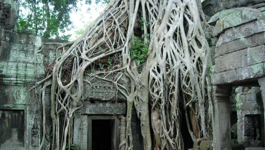
Ta Prohm, a temple set in the backdrop of a jungle a kilometer east of
Angkor Thom, was one of the highlights of my visit to Siem Reap. Ta
Prohm (Old Brahma), originally called Rajavihara (Royal Monastery),
was built during the 12th and 13th centuries. A notice board at the
entrance announced in English, Hindi, and Cambodian that the temple
was being subject to restoration: "India Cambodia co-operation project
for conservation and restoration of Ta Prohm temple". During the
half-kilometer trek from the west gate to the main temple, I saw a
group of landmine victims huddled together singing and playing musical
instruments. Their music CDs were on sale and they requested
donations. Dozens of kopac, banyan, and papal trees grew inside the
compound and provided welcome shade from the scorching Cambodian
sun. It was the middle of the rainy season and the heat seemed
preferable to a mobility-inhibiting downpour.
Trees grew through and around the walls, roofs, and floors of the
temples of Ta Prohm, breaking and bending the monument. Roots
penetrated the sanctum sanctorum; branches clutched the structure.
Wondrous natural sculpture stood alongside brilliant man-made
sculpture, and complemented it.
I saw an Indian engineer and his 3 Cambodian assistants involved in
restoration work inside the temple: a woman held an umbrella over the
engineer; a boy operated a ladder; a man shouted out measurements,
which the engineer recorded in his notebook.
A swarm of vendors enveloped tourists exiting Ta Prohm. Items on sale
ranged from T-shirts, magnets, and souvenirs, to local musical
instruments and bottled water. Several beggars waited alongside the
vendors for the occasional Real or cent. Every cent in Cambodia was
hard earned.
While leaving the Angkor complex in a van to find some lunch, I saw a
long queue of people waiting in front of a pediatric hospital. Parents
held their kids under umbrellas, shielding them from the afternoon
heat. The van driver said that the hospital was sponsored by the Swiss
government and offered free care.
After lunch, I found my way to an ATM to refuel my wallet. The machine
spit out only U.S. dollars; there was no option to request Reals. This
was the first time I had used my ATM card in a country and obtained
the legal tender of another country!
My destination for the remainder of the day was the glorious Angkor
Wat. This famous temple was built by King Suryavarman II in the early
12th century, and pre-dated Angkor Thom by a few decades. Suryavarman
dedicated Angkor Wat to the Hindu God Vishnu, and called it Preah
Vishnuloka (the world of Lord Vishnu), after the presiding deity. The
temple is said to represent Mount Mahameru, the abode of the Devas.
Like several other originally Hindu structures in the Angkor complex,
this temple was re-dedicated to Therevada Buddhism in later years.
I walked across a causeway over the moat surrounding the Wat and
reached the outer wall of the complex. A battle scene from the
Ramayana was etched over the ingress arch. Carvings of Apsaras, lotus
motifs, flaming flowers, soldiers, and mythological characters such as
Garuda, were ubiquitous on the walls on close inspection. Each carving
was distinct; each Apsara looked different. As I continued through the
long courtyard towards the main temple, Angkor Wat's tower quincunx
sprang into view. Especially delightful was the view across a water
body to the left of the courtyard. The five towers of Angkor Wat, as
well as their symmetric reflection in the pond, revealed a surreal
sight.
Near the entrance to the main temple was an ancient tall broken statue
of Lord Vishnu. The first corridor wall was adorned with carvings that
narrated episodes from the Ramayana. One scene depicted Rama perched
on the shoulders of the monkey god, Hanuman, fighting with bows and
arrows against Rakshasas (demons). Rama's brother Laskhmana was
engaged in combat behind him. Another carving showed the demon king
Ravana fighting from his chariot.
Further inside was an "echo chamber" that was reputed to cure heart
disease. If you beat your upper chest - and only the chest - the
resulting sound waves resonated with a distinct echo. Patients of yore
prayed for cure after beating their chests from inside the echo
chamber. Another room was said to have held 1000 statues of Buddha at
one point of time. All the statues had either been stolen or shifted
to museums.
Reconstruction and repair work was in progress in the inner temple. I
could see workers moving huge stones by rolling them over logs. Some
of the inscriptions in the temple pillars were said to be
transliterations of Sanskrit slokas (verses) in Khmer language. Khmer
language has its roots in Sanskrit and Pali. French colonists could
not alter it the way they had Latinized the Vietnamese script.
There was an active Buddhist temple in one portion of the wat. Several
monks were in the vicinity. Someone remarked that Buddhist monks in
Cambodia were not allowed to kill animals, but could eat meat. Except
for ten animals, that is. The proscribed list included tigers,
elephants, and crocodiles.
As I reluctantly left Angkor Wat after a few hours, I noticed that the
five towers of the temple had turned into brownish gold as if by
magic. That change in hue was because of the late afternoon sunlight.
It's said that the Wat used to sport a golden color when it was
built. At that time, there was no moss or damage - smooth stone
reflected bright sunlight.
Back in Siem Reap town, I noticed that though traffic plied on the
right side of the road - unlike in many other Asian countries due to
the French legacy - only half the cars on the roads were left-hand
drives. It seemed dangerous to drive on the right side of a two-lane
road on a right-hand drive, but apparently that was legal (or not
enforced) in Cambodia.
Cambodia might be in abject poverty, but apparently possessed two deep
rooted pillars of culture - architecture and language - seeded from
the Hindu religion. Interestingly, if you sweep from the Indian
subcontinent towards the east, you'll notice a gradual change in the
Hindu influence. India, of course, is where both Hinduism and Buddhism
originated. In Burma, Thailand, and Cambodia, the lines get blurred
between the two religions. If you talk to the average Cambodian on the
street about religion, you are likely to hear the opinion "Buddhism,
Hinduism, same same". Further east, the lines get thicker. Many
Vietnamese, for example, have not even heard of Hinduism.
I made an interesting acquaintance at my hotel that evening: a
Canadian machine operator from Montreal in his mid-fifties. He was a
Quebec separatist and declared that referendums to secede from Canada
always got narrowly defeated because of immigrant voters. He had
married at the age of 18 and had divorced at 20. Decades later, he had
met a Vietnamese woman from Saigon over the Internet. She had
advertised for Canadian suitors from Quebec after learning the French
language in preparation. One thing led to another and he was finally
getting married to her the following week at Saigon. He and his lady
were on a pre-marriage honeymoon to Cambodia. He had already obtained
permission for the marriage from Canadian authorities in Saigon and
hoped that his partner would be granted Canadian citizenship soon. The
would-be-bride had had an eventful past. She was born in Cambodia, but
had migrated along with her family to Vietnam in the early 1970s in
the midst of the American-Vietnam war to escape Khmer Rouge's
brutality. The would-be-groom commented that he was a skilled worker
and made good money, but expressed reluctance to pay for the wedding
lunch - Vietnamese custom called for the bridegroom to bear marriage
expenses.
Lunacy of Pol Pot
The plan that I had charted for the next 2 days was: Start from Siem
Reap in a bus early in the morning to Phnom Penh and reach the capital
before noon, roam around Phnom Penh for the rest of the day, sleep in
Phnom Penh, and depart the following day to Saigon.
I got acquainted with two fascinating co-passengers on the bus to
Phnom Penh: a 72 year old Australian and his wife. The Aussie man had
frequented Phnom Penh in the 1970s on business trips. When I remarked
that he must have visited Angkor Wat several times, he replied that
this was his very first visit to Siem Reap. Had he traveled in a bus
like this during those days, he would have been shot dead within 10
miles of Phnom Penh, he said. "It would have been utterly, thoroughly,
unthinkable to visit Angkor during the lunacy of the Khmer Rouge", he
exclaimed. Coming from him, it couldn't have been more authentic. For,
in the 1960s, he had indulged in adventure like there was no tomorrow.
He had driven from Helsinki in his German car through a large section
of the USSR. He had motored from Calcutta to Lahore through the Indian
subcontinent. He had visited several countries in North Africa and all
parts of North America. He had been to every nook and corner of
southeast Asia. The couple next planned to travel the Trans-Siberian
railway.
I reached Phnom Penh as planned by mid-day. After lunch, I hired one
of the tuk-tuks standing outside the restaurant for the rest of the
day. The driver was Dara, a strikingly handsome man with a smiling
face, who spoke passable English. My first stop was the Tuol Sleng
genocide museum, a notorious prison used by the Khmer Rouge regime.
The Khmer Rouge (Red Khmers) were members of the Communist Party of
Kampuchea whose ideological lunacy led to the genocide of 2 to 3
million Cambodians. Led by Pol Pot (whose original name was Saloth
Sar), the Khmer Rouge era (1975-1979) saw a relentless attempt to
create an agrarian-based society where the entire population worked in
collective farms. City-dwellers were expelled to villages. Currency
was abolished, so were schools, law courts, and markets. Religious
practise was forbidden. The calender was remade starting from Year
Zero with the goal of "restarting civilization". Each citizen was
asked to labor in the fields and grow food. Intellectuals - engineers,
doctors, scientists, monks, government leaders, teachers, foreigners -
were considered enemies and executed.
Tuol Sleng was a former school that was converted to a prison named
S.21 (Security Office 21) by the Khmer Rouge. My visit to Tuol Sleng
started at Building "A" that held 20 classroom-turned-cells in 3
floors. The building was primarily used to jail, interrogate, and
torture prisoners who had been high ranking officials. Between
Building "A" and Building "B" was a display board that listed ten
regulations enforced in the prison: "(1) You must answer according to
my questions - don't turn them away. (2) Don't try to hide the facts
by making pretexts, you are strictly prohibited to contest me. (3)
Don't be a fool for you are a chap who dare to thwart the revolution.
(4) You must immediately answer my questions without wasting time to
reflect. (5) Don't tell me either about your immoralities or the
essence of the revolution. (6) While getting lashes or
electrification, you must not cry at all. (7) Do nothing, sit still
and wait for my orders. If there is no order, keep quiet. When I order
you to do something, do it right away without protesting. (8) Don't
make pretext about Kampuchea Krom in order to hide your secret or
traitor. (9) If you don't follow all the above rules, you shall get
many lashes of electric wire. (10) If you disobey any point of my
regulations you shall get either ten lashes or five shocks of electric
discharge."
Nearby stood a pole labeled "The Gallows". A notice posted next to the
contraption described it this way: "This pole with cables attached to
it had been used by students to conduct their exercise. The Khmer
rouge utilized this place as interrogation room. The interrogators
tied both hands of the prisoners to the back by a rope and lifted the
prisoners upside down. They did this until the prisoners lost
consciousness. Then they dipped the prisoner's head into a jar of
smelly, filthy water, which they normally used as fertilizer for the
crops in the terrace outside. By doing so, the victims quickly
regained consciousness, and the interrogators continued their
interrogation".
The rooms in Building "B" displayed photographs of hundreds of victims
who were imprisoned in S.21 and subsequently executed. A box in one of
the rooms was stuffed with clothes worn by inmates. Photographs of
killing fields were on display that showed heaps of bodies and skulls
of thousands of Cambodians - young and old, male and female. A few
statues of Pol Pot were housed inside a cage. Information boards
affixed to the walls of some rooms described the chronology of
Cambodian history from 1953 to 1979. Narration started with the events
of 1953 when King Norodom Sihanouk promulgated a decree declaring the
nation to be in danger and dissolved the national assembly. It ended
with the capture of Phnom Penh by Vietnamese forces in 1979. The
international community and the United Nations condemned the
Vietnamese invasion and continued to recognize the Khmer Rouge as the
legal government of the Cambodia for the next fourteen years!
A section titled "Leaders of the Communist Party of Kampuchea
1976-1978", described the lives of the two main leaders of Khmer Rouge
- Pol Pot and Son Sen. Another section described the evacuation of
Phnom Penh in April 1975. This was in line with Khmer Rouge's belief
that urban living was evil and that cities had to be emptied. Khmer
Rouge troops triggered the evacuation by announcing over loudspeakers
that the U.S. air force was preparing to bomb Phnom Penh.
Khmer Rouge's philosophy was to create a nation of peasants using
collective farms. Citizens had to renounce their property to be used
collectively. People in cooperatives were supposed to live and eat
together. The family as a unit of society was frowned upon. The Khmer
Rouge wanted to create a classless society, but ended up creating two
new classes: the "base" people and the "new" people. Base people were
those who had lived in rural areas controlled by the Khmer Rouge
before they captured Phnom Penh in April 1975. New people were those
who had been evacuated from the cities and towns after April 1975.
Base people were given full rights, while new people were treated
harshly and looked at with suspicion.
Classrooms in the ground floor of Building "C" were divided into
small-sized brick cells, 11 per room. The first floor was similar,
except that the cells were made of wood and there were 16 of them in
each room. The top floor housed a series of photographs captured by a
member of a Swedish delegation that visited Cambodia in 1978. At the
time, the photographer had been a supporter of the Khmer Rouge regime,
but thirty years later, he had retrospected how that had been
possible. As a result, each photograph was tagged with sets of
comments under the headings, "Thoughts from 1978" and "Thoughts
Today". Sample a few:
- A photo titled "A young brigade boarding a bus North of Phnom Penh". Thoughts from 1978: "These people did not seem stressed, oppressed, starving, or unhappy". Thoughts Today: "Maybe we met only 'old people' and Khmer Rouge cadre who were comparatively well off".
- A photo titled "A typical stop on the trip to film and take photos". Thoughts from 1978: "We are allowed to stop anywhere and film what we want. This can't be a show only for us". Thoughts Today: "The things we were shown did disprove some of the rumors about Cambodia. But we were not shown everything, and the things refugees were saying were compatible with what we saw. We should have realized the tour's limitations". More Thoughts at the Time: "Our main guide talked to us about creating the 'new man'. Many earlier revolutions held this dream - often with a naive idea about making quick changes in a culture that has existed for thousands of years. I don't think you can create a 'new man' in 3 years! How can our guide have believed that?"
- A photo titled "Children at the cooperative - protecting the crop". Thoughts from 1978: "Poor farm children worked the fields in Sweden too - before we were prosperous enough to put everyone in school". Thoughts Today: "I know now that many children lost their parents and never got the chance to grow up in a safe environment".
I continued on to Building "D". A map showed the population expulsion
route from cities and towns to villages. An artist's rendition showed
Khmer Rouge soldiers grabbing a baby from a mother and caning
her. Modes of torture were described: slicing finger nails with
pliers, scorpions held by pliers biting women's nipples, men being
whipped, and blindfolded prisoners beheaded in assembly line fashion.
One room contained glass enclosures holding skulls and bones. Gunshot
wounds could be clearly seen on many of them. Some skulls had blunt
impact trauma, indicating that the victims had been bludgeoned to
death. Others had deeply incised or hacking wounds. A large landscape
photograph affixed to the wall showed countless skulls and bones
heaped on a field.
Phnom Penh's S.21 brought memories of Warsaw's Pawiak prison. Both
were epitomes of cruelty and horror, separated by a few decades and a
continent. On the way out of S.21 was a museum shop from where I
purchased a DVD titled "Killing Fields". The subject of the DVD was
the killing fields of Choeung Ek situated 15 kilometers southwest of
Phnom Penh, where 20,000 civilians had been killed and buried in mass
graves.
I asked Dara to next tuk-tuk me to Choeung Ek, simply known as Killing
Fields. Many of those executed in Choueng Ek had been transported from
S.21 after undergoing torture and interrogation there.
At the entrance to the Killing Fields stood a tall Buddhist Stupa
[Footnote: Buddhist structure built in the shape of a heap] having
glass sides. The stupa held innumerable skulls of victims of the
genocide. The first level of skulls was labeled "Juvenile Female
Kampuchean from 15 to 20 years". The mountain of skulls in the tower
was a sobering testimony to the insanity of the murderous Pol Pot
regime. An information board outside the skull tower stated: "Choeung
Ek Genocidal Center is a unique and special place which reflects the
most barbarous and cruel crime committed by the ultra communist Khmer
Rouge regime during 1975-1979. Here, about 20,000 people including
foreigners were executed and murdered. Obviously, 129 mass graves and
about 8000 human skulls at the site bear testimony to this unspeakable
crime. In order to remember the spirits of victims at the site as well
as over 3 million victims throughout the country, a memorial was built
in the center in 1988. Please pay respect to the victims by offering
flowers and lighting an incense and candle in front of the charnel
before starting your visit at the site".
I followed the trail behind the stupa to the mass graves and execution
sites. A placard erected beside a giant tree spoke: "Magic tree - The
tree was used as a tool to hang a loudspeaker which made sound louder
to avoid the moan of victims while they were being executed". A glass
enclosure in another part of the trail contained bone fragments
unearthed during an excavation in 1980. The area had thick tree
cover. Placid waters of a lake occupied part of the ground. There were
not many visitors around. As I trekked my way alongside the boundary,
a group of scantily clad kids playing outside the wired fence
approached me, posed for photographs, and asked for pocket money.
A small plot of land was labeled "Mass grave of 166 victims without
heads". Another similar area was marked "Mass grave of more than 100
women and children, majority of whom were naked". A nearby tree had
this name plate: "Killing tree against which executioners beat
children".
The erstwhile executioner's office was described as follows: "Here was
the place where executioners stationed permanently at Choeung Ek
worked. The office as well as the killing fields were equipped with
electric power which enabled them to conduct executions and to read
and sign the rosters that accompanied the victims to the site at night
time". Another area held the following note: "Here was the place where
victims transported from Tuol Sleng and other places in the country
were detained. Usually, when the truck arrived, the victims were
executed immediately. However, as the number of victims to be executed
was increased up to over 300 per day, executioners failed in attempt
to kill them within a day. That is why they were detained for
execution the next day. The detention was constructed from wood with
galvanized sheet roof..".
Here's an extract from the contents of a particularly moving statement
displayed in a portion of the field: "Even in this 20th century, on
Kampuchean soil the clique of Pol Pot criminals had committed a
heinous genocidal act. They massacred the population with atrocity in
a large scale. It was more cruel than the genocidal act committed by
the Hitler fascists.. With the commemorative stupa in front of us, we
imagine that we are hearing the grievous voice of the victims who were
beaten by Pol Pot's men with canes, bamboo stumps or heads of hoes,
who were stabbed with knives or swords. We seem to be looking at the
horrifying scenes and the panic-stricken faces of the people who were
dying of starvation, forced labor, or torture without mercy upon their
skinny body. They died without giving the last word to their kith and
kin. How hurtful those victims were when they got beaten with canes of
hoes and stabbed with knives or swords before their last breath went
out. How bitter they were when seeing their beloved children, wives,
husbands, brothers, or sisters were seized and tightly bound before
being taken to the mass grave!.."
Seeking relief from the violent ambiance, I fled in the tuk-tuk to the
Pagodas of the Royal Palace in central Phnom Penh. I took a series of
photographs of the cityscape that unfolded before me as we drove: A
lady carried her 3 school kids on a mobike. Shops and apartment
buildings dotted the roads. A restaurant named "Bluetooth" advertised
"Holland Beer". A bunch of signs at a road junction pointed the way to
Mao Tse Toung Blvd, Olympic Stadium, Central Market, and Orussey
market. A family of 6 passed by in another tuk-tuk. I paused at a
nearby post office to purchase some stamps. My tuk-tuk soon drove by
the Independence Monument that stood at the intersection of Sihanouk
Blvd and Norodom Blvd. The lotus-shaped edifice was constructed in
1958 to mark Cambodian independence from France. We next crossed the
Tonle Sap river, passed the imposing National Assembly building, and
reached the palace compound that housed a collection of beautiful
royal residences and magnificent temples.
The entrance ticket offered a capsule of the palace's history: "The
Phnom Penh Royal Palace was constructed twice. The first construction
took place in 1434. Then the royal family moved to Oudong, north of
Phnom Penh. The second palace was built in 1866 and stands to the
present day. Formerly, the Royal Palace was called Preah Borom Reach
Vang Chatomuk Noughkul. The name was so given due to its location near
the intersection of four rivers: the upper Mekong, the Toule Sap, the
lower Mekong, and the Toule Bassac. The Royal palace compound is 435
meters long and 421 meters wide, and a high wall, which is decorated
with Seima shapes, surrounds the complex. It was constructed during
1866-70 during the reign of His Majesty King Norodom [Footnote:
Considered to be the first modern Khmer king. Norodom is credited with
saving Cambodia from being partitioned between Siam and Vietnam by
placing the country as a French protectorate.]. Most of the buildings
include magnificent sculptures and are characterized by many tiered
roofs and topped by towers which are symbols of prosperity. The
previous buildings were wooden and then reconstructed in concrete, but
their original forms have been preserved."
One of the first structures inside the royal palace compound was the
Throne hall where kings kept court. The hall is now used for religious
ceremonies. A highlight of the palace was the Silver Pagoda situated
to the north of the complex. The Pagoda's main temple was Wat Preah
Keo. Paintings from mythology embellished the walls of the porch
surrounding the Pagoda. Near the entrance was a temple dedicated to
the mother cow. The lord of Wat Preah Keo was a magnificent Buddha
mounted on a high golden pedestal. Several other Buddha statues
surrounded the main deity.
Near Wat Preah Keo was a hillock that symbolized Mount Kailash, the
abode of Lord Shiva. A Buddha graced the temple on top of the
mound. On the slope was a statue of the elephant-headed Hindu God,
Ganesha.
After wandering the beautiful buildings, pavilions, stupas, and
gardens for another hour, I exited the palace into the midst of an
army of vendors selling souvenirs, and dodged my way to my waiting
tuk-tuk. My next destination was Wat Phnom, the tallest religious
monument in Phnom Penh. As I tuk-tuk-ed along, I noticed that several
road names in the city were prefixed with "Preah", which means
"sacred" in Khmer, a word now synonymous with Buddha. Some streets
were named after statesmen such as Jawaharlal Nehru, Charles De
Gualle, and Mao Tse Tung. I caught glimpses of dirty slums alongside
foul canals as we drove on.
Wat Phnom was originally constructed 600 years ago on a man-made
hillock. The dome of its main stupa was visible from afar. The park
area around the small hill seemed to be a gathering space for
townsfolk. I climbed the temple steps passing several monkeys on the
way. Inside the Wat was a sublime golden Buddha clothed in a yellow
robe. Huge yellow candles stood on either side of the deity. The
temple walls were embellished with paintings, each of which captured a
slice of mythology.
Before calling it a day, I invited Dara to join me for a cup of
coffee. He stopped at a western cafe, but I asked him to take me to a
place that offered genuine Cambodian coffee. Dara then took me to
"Cafe Darling" located in a non-touristy market area of the town. As
we sat there, Dara started opening up and talked about his family, his
earnings, and his aspirations. He was 47 years old and was married
with a 4 year old daughter. Dara said he worked seven days a week and
made about 200 dollars a month. He paid a rent of $80 for a house that
had a single room and a kitchen. His daughter's school fee was another
$30. Dara said he couldn't break even without earning $200 a month. He
owned his tuk-tuk, which he had purchased for $800. Dara's ambition
was to purchase his own house. A house similar to the one he rented
would cost him $10,000, he rued, adding that he was quite far from
achieving his dream.
Dara then remarked that though he regularly carried tourists to the
S.21 prison and to the killing fields, he could not bear to even
glance inside. He then told me about his parents and his sister and
his brother. All four of them had been caught by the Pol Pot regime
and imprisoned in the S.21 prison in 1977, when Dara was 14 years
old. And all of them had been executed in the killing fields of
Choeung Ek.
A Brief History of Cambodia
| 12th century | Reign of Suryavarman II and Jayavarman VII. Angkor Wat built during the former's reign; Angkor Thom constructed during the latter's rule |
|---|---|
| 15th century | Thai invasion of Cambodia |
| 17th century | Vietnam conquers Cambodia |
| 18th century | Vietnam annexes the Mekong delta from Cambodia |
| 19th century | Cambodia frees itself from Vietnamese occupation. A few years later, the country becomes a French colony |
| 1941-45 | Japan occupies Cambodia during the second world war |
| 1953 | Cambodia declares independence from France |
| 1975 | Khmer Rouge captures Phnom Penh |
| 1979 | Vietnamese army captures Phnom Penh and drives out the Khmer Rouge |
| 2004 | King Norodom Shihanouk abdicates and his son Norodom Sihamoni is crowned |
Cambodia in Numbers
| Cambodia | India | USA | |
|---|---|---|---|
| Area | 0.18 mil sqkm | 3.3 mil sqkm | 9.8 mil sqkm |
| Population | 14.5 mil | 1,116 mil sqkm | 307 mil |
| Population Growth | 1.75% | 1.55% | 0.98% |
| Literacy | 74% | 61% | 99% |
| Life Expectancy | 62 yrs | 69 yrs | 78.1 yrs |
| GDP (PPP) | $28 bil | $3.267 tril | $14.3 tril |
| GDP per capita | $2000 | $2800 | $47,000 |
| Cellular connections | 2.6 mil | 362 mil | 255 mil |
| Internet users | 70,000 | 80 mil | 233 mil |
| Railway | 600 kms | 63,000 kms | 226,000 kms |
| Religion | 95% Buddhist 2% Muslim |
80% Hindu 13% Muslim |
50% Protestant 24% R Catholic |
Photographs
Have a look at my photo gallery for the snaps I took in Cambodia.